 Some months back, a some of the Austin Flickrites were talking about old and abandoned places to go shooting at. It was an interesting discussion, bringing to light some of the seedier and forgotten places within Austin and surrounding areas. One of the places that was brought up was an old City of Austin sewage lift pump station. These stations are placed around the city to help move waste towards East Austin where the big sewage treatment plants are located at. Smelly, dirty work, mind you.
Why was this so interesting, though? Long abandoned, the building had been gutted and all the moving parts removed and abatement done to clean it up. But, over time, the building was overtaken by the lives of random taggers and graffiti artists. A huge, empty, white canvas of brick and concrete, out in the middle of nowhere.
 It was secluded and "easy" to access. Sitting on the old, abandoned Grove Drive in East Austin, no one paid much attention to it. It was surrounded by park land and overgrown with weeds, trees, and mustang grape vines.
There are two ways to access the area. The first one goes through Roy Guerrero Colorado River Park. Grove Drive runs right through it; if you look closely you can see the main path is a narrow pavement road, cracked and potholed. Ragweed runs high along both sides of the dead roadway. A half mile trek from the parking area will lead you to a deep creek bed, covered with a one lane bridge. A short hop, skip, and a jump over the bridge (watch out for the troll!) and you would come upon the lift pump station.
Well, when this originally came up, I took a short hike out there to figure out where exactly this thing was. It was late summer and there were signs of cleanup in the park and impending construction. The first time I came out, it was nearing sun down and having never been out there before, I opted to leave my camera equipment back at the car. I wasn't sure how far I would have to walk, who I'd run into, or how long I'd be out there thanks to the setting sun. I vowed to come back "soon".
When I got home that night, I started searching for info on the lift pump station. My Google-fu didn't fail me; I discovered that it was the Montopolis Lift Station and it was scheduled for demolition sometime in the 2007/2008 time frame. With it being an interesting place to photograph, I knew I wanted to go back to it and do it before it was torn down. Sadly, I never made it back in time.
 Tonight, feeling a bit out of sorts with my latest photography, I made the realization that I hadn't really taken any photos just for me. I remember reading a recent blog posting about this very thing and felt that I really needed to re-center and just go out by myself and shoot for the fun of it. I remembered this old lift station and thought, "Bingo!" I'll go back and poke around that. I have all my lighting gear, it's getting later in the evening so I'll have more control over the light. Off I went.
Arriving, again, about 30 minutes before sunset I hoofed it over to the bridge only to see my one lusted-for subject gone. In it's place was fence, landscape mats, and fresh growing grass. I wanted to kick myself for being so incredibly lazy. Procrastinating baaaaaad!
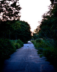
Being the intrepid explorer (feeling bummed and stupid is more like it), I started trudging back along Grove and photographing the path as I went. Once you round the curve near the bridge, Grove is a fairly straight run, right into the orange glow of the setting sun. You can see how overgrown the area is. Piles of dead trees and scrub brush from a big cleanup still litter the roadside. The mounds are 8-10 feet high and go on for 40-50 yards at a time. They've been there awhile, at least since my first visit to the pump last year.
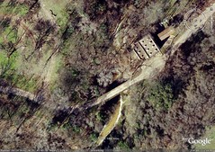
 As I was walking back, I saw this semi-clear path shoot off towards the river. Comparing to Google's aerial photos, that path led to a trail running along the river. The aerial photo was taken a few years back. The land has shifted since then, taking 15 or 20 feet of path with it. It just ends in empty space. No guard, no rail. Just ... walking along and then all of a sudden, you're discovering gravity and hitting the river bed below.
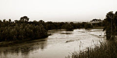
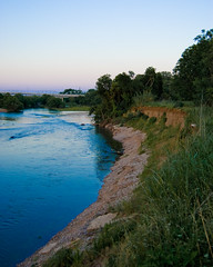 Thankfully, it was still light enough out to see it. I gingerly tested the ground to make sure it wasn't going to collapse out from under me as I neared the edge. It was a good 15-20 feet down and I wasn't looking forward to climbing out with a broken leg. This was quite a view. To the east was the old bridge that crosses the Colorado River just north of the Highway 183 and Montopolis interchange. This would be an amazing photo for sunrise. Sadly, I don't know that I could get out here early enough to take it. Especially if I had to access this path via the park. It's a fun thought. I could certainly try the hike from the 183 side (assuming I thought my car would be remotely safe parked on the road).
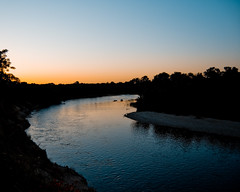 To the west is a bend in the river. The glowing orange of sunset reflected off the water. The water was moving at a pretty good clip. It was oddly peaceful out there. Just the sound of birds, crickets, and the water. With the occasional airplane moving across their approach vector which happens to travel along 183. As I was taking photos of the western bend, I noticed some movement off in the water. I couldn't tell what it was so I switched lenses and, in the fading light, discovered a man playing with his two dogs down on the river bed. The two dogs were running back and forth, frolicking in the cool flow of water.
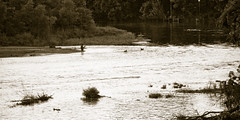 I sat down on the edge of the path, not quite hanging over it, looking for a way down to the river bed. There was an animal trail leading off towards the west, but it was overgrown enough that I didn't trust going down there in just shorts. Plus, it was pretty close to the edge. Not so intrepid now, huh? As I was following the trail I caught sight of a pile of rocks down next to the water, some 100 feet away. They had been arranged much like you would see two tombstones, a husband and wife, lying next to each other in the rocky earth. It was creepy. With the light slipping further and further away, I wasn't able to get a photograph of it. I want to go back and get a closer look at them to see what they really are.
After awhile, I decided to pack my gear up and run out the rest of the main trail through the park. It was an extension of Grove. If you look at aerial photos of the area, you can see that the trail extends fully to the park at Pleasant Valley Road where the dam is. Walking along it, well into dusk now, I noticed movement out in the brush to my right. Two shapes frozen and alert. It was the dogs from earlier. They watched me and soon I wandered out of range. I kept walking for another ten minutes, wanting to see what was just around the next bend. I hadn't looked at the aerial photos for quite awhile so I couldn't remember where this all went. Taking it slow and just listening and watching, the
 wooded areas began filling with lightning bugs. If I had the tripod, I would have attempted a long shutter shot in the darkness just to see if I could capture them. When I came upon a downed tree that covered most of the path, I decided it was time to turn around and head back to the car. As the sun finished setting, the moon began it's rise in the east, cresting the tree tops and launching itself fully over the old, abandoned Grove.
As I was sitting on the ground, taking this photo, I was thinking back about not taking photos when I had the chance. It kind of irks me that I let my procrastination get the better of me at times. It takes a good, swift kick in the ass like this to make me realize that there are no second chances. If you can do it now, do it. Don't wait. Sure, you might be lucky and find your subject there when you get back to it, but really, it won't be the same. The light will be different or your mood will be changed. Maybe you'll have the wrong lens or there'll be a swarm of blood thirsty gnats charging forth to suck you dry, causing you to tremble just as the shutter clicks (ooh, instant blur!). You won't be able to recreate it exactly as before, so do yourself a favor and take the damn photo. You'll thank me when you've gone back to discover that the image you want can never be created because your subject has been demolished and destroyed.
So yeah, take the damn photo.
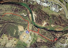
A bigger view of the park. The red path is what I ended up walking tonight, just exploring until I got tired. The circle on the far right is where the lift station used to be. The blue circle is where my car was.

No comments:
Post a Comment